Advertisement
Weatherman issues heavy rainfall and strong winds alert across the country
Friday 24th April, 2026 07:47 PM|

The Kenya Meteorological Department has issued an advisory warning of heavy rainfall, strong winds, and large waves expected across multiple parts of the country from Friday evening, April 24, 2026, to May 1, 2026.
In Advisory, Kenya Met indicated that rainfall exceeding 20 mm in 24 hours is expected in the Highlands West and East of the Rift Valley, Lake Victoria Basin, Rift Valley, Southeastern Lowlands, Northeastern, and Northwestern regions.
The heaviest rainfall is forecast between April 26 and April 28, 2026. The Coast is also expected to receive heavy showers of more than 20mm daily up to April 27, 2026.
The advisory further warns of strong southerly to southeasterly winds exceeding 25 knots (12.86 m/s) along the Coast, Southeastern Lowlands, Northwestern, and Northeastern regions. Large ocean waves exceeding two metres are expected along the coastal waters during the period.
You Might Also Like


“The heaviest rainfall over these regions is likely to be received from Sunday, 26th to Tuesday, 28th April 2026. The Coast is likely to continue experiencing heavy rainfall of more than 20mm in 24 hours up to 27th April 2026,” read the Kenya Met statement in part.
Weather outlook and affected regions
The alert, which carries moderate probability and moderate to heavy severity, identifies several counties expected to experience significant weather impacts.
These include Turkana and Samburu in the northwest; Migori, Kisumu, Homa Bay, Kakamega, Bungoma, and other counties around the Lake Victoria Basin; as well as Elgeyo Marakwet, Baringo, Nandi, Uasin Gishu, Nakuru, and Narok in the Rift Valley.
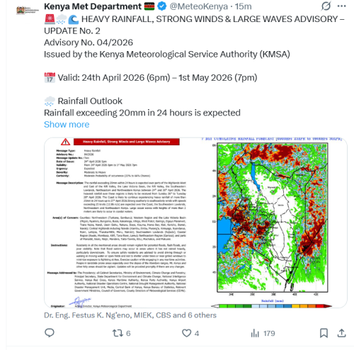
Other affected areas include Nairobi, Kiambu, Murang’a, Nyeri, Kirinyaga, Embu, Meru, Laikipia, and Nyandarua in the Central Highlands; Kajiado in the southeastern lowlands; and coastal counties including Mombasa, Kwale, Kilifi, Tana River, and Lamu. Northeastern counties such as Garissa, Wajir, Mandera, and parts of Isiolo, Marsabit, and Kitui are also on alert.
Residents have been advised to remain vigilant due to possible flash floods, poor visibility, and water accumulation in low-lying areas. Flood waters may affect downstream areas even where rainfall is not directly experienced.
Safety guidance and risk areas
Kenya Met has cautioned against walking or driving through moving water and advised residents to avoid sheltering under trees or near metallic structures during thunderstorms due to lightning risk.
Communities in landslide-prone areas, particularly the Aberdare ranges, Mount Kenya slopes, and other hilly regions, have been urged to take extra precautions.
Maritime operators and coastal communities have also been advised to exercise caution due to expected rough sea conditions and large waves.
El Niño outlook and preparedness
The advisory comes as the World Meteorological Organization reports a likely El Niño development between May and July 2026, following warming of sea surface temperatures in the central and eastern equatorial Pacific. The update indicates potential strengthening of the system over the coming months.
Kenya experienced severe flooding during the 2023–2024 El Niño episode, which resulted in loss of life, displacement, and damage to infrastructure and agriculture.
Authorities, including the National Disaster Operations Centre, Kenya Red Cross, and county governments, have been placed on alert.
Kenya Met has stated that further updates will be issued as weather conditions evolve, with emphasis on early warning and preparedness to reduce risks associated with extreme weather events.
Author
Latest News


Advertisement
More on News