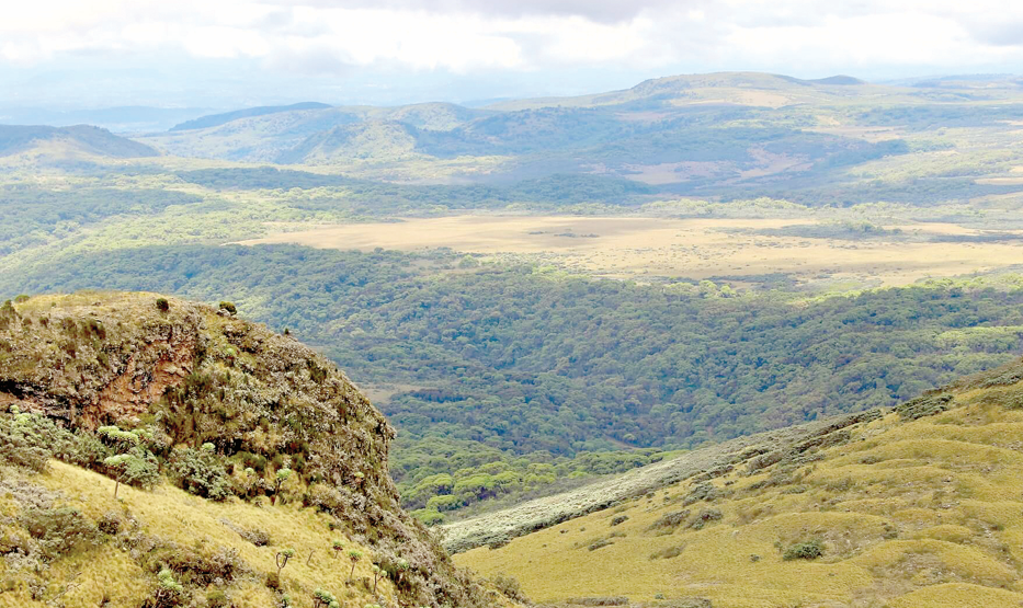
Concerns over Mau Mau Road’s threat to wild animals, forests and watershed

Stretching 25 kilometres across the Aberdare National Park, it is taunted as the highest road in Africa, with the highest peak sitting at 3,200 metres above sea level.
But the proposed Ihithe-Aberdare Forest-Kahuruko-Ndunyu Njeru Road now threatens the existance of thousands of wildife species living in this forest, water catchments and the entire biodiversity.
The proposed road will meander through the closed Aberdare canopy, with its proponents terming it a missing link between Nyandarua and Nyeri counties, thereby spurring growth. But to those against it, the project is an ecological disaster that will fragment the Aberdare ecosystem.
The National Environment Management Authority (NEMA) has expressed fears that the Sh4.4 billion project will spell doom to the majestic peaks, picturesque, steep forested ravines, and open moorlands.
Some of the wildife found at Aberdares include elephants, black rhinos, leopards, spotted hyenas, olive baboons, black and white colobus monkeys, buffalos, warthogs, bushbucks, and endangered mountain bongos is mind boggling.
“The proposed project will have massive impacts on the natural forests during construction. Endangered tree species are also most likely to be affected,” reads a caution letter from NEMA on the proposed project.
NEMA findings are supported by the Environmental and Social Impact Assessment (ESIA) report conducted by Norken International Ltd, which indicates an approximate area of 385 acres along the existing road is under the project footprint.
Ironically, Norken International Ltd was contracted to conduct the ESIA study and also design the road. To stump the ecological disaster facing one of the biggest water towers in the country, the report reveals around 257 acres of vegetation is lying on areas that will potentially be cleared.
“Out of this, 185 acres of bamboo will be destroyed, 35 acres of forest, and another 35 acres of moorland will potentially be destroyed,” part of the ESIA report reveals.
Dr Paul Matiku, Executive Director at Nature Kenya says the road is not for carbon sequestering. “Kenya is a leading country that wants to be carbon neutral, the country needs roads, but not across the forest and the park,” Matiku says.
Though at incubation stage, the authorities and scientists term the road a “black snake of the Aberdares” whose venom to the fragile ecosystem will be felt far and wide. Rhino Ark Kenya Chief Executive Officer Christian Lambrechts, says the proposed upgrading of the roads is not in line with existing policies and laws.
“By clearing at least 185 acres, the road will undermine the recent commitments made by President William Ruto to increase tree coverage by more than 30 per cent by 2032, by planting 15 billion trees,” Lambrechts says.
He further says the project also goes against Vision 2030 blueprint to restore Kenya’s five main water towers (including the Aberdares) entitled the Water Catchment Management Initiative, due to their critical water catchment functions.
Under the 2015-2045 National Spatial Plan, it ranks the water towers, wetlands, and natural forest as the number one protection areas where ‘development is not permitted in these areas except for the purpose of eco-tourism and research’.
“Aberdares ecosystem is a global park because it is home to species of global significance and without it, Kenya would have let down the global community,” Matiku says.
He notes that by interfering with it, the country is negating its commitment to achieve the Sustainable Development Goal (SDGs) number 6, which touches on access to safe water, sanitation and hygiene as the most basic human need.
Source of water
He notes that the forest is a sink for water coming from the moorlands that comprise bogs, wetlands, and peat lands, which oozes out during the dry season serving pastoralists as far as Tana Delta.
The ecosystem is the source of Athi River and the Ewaso Nyiro River, which are lifelines for millions of Kenyan households living downstream, especially pastoral communities.
“It is a water catchment of Ndakaini and Sasumua dams, which provides the lion’s share of the water used in Nairobi City and together with Mt Kenya, they contribute 70 per cent of the country’s hydro-power produced by Tana River, Seven Forks” Matiku explains.
He adds that Malewa River on the western side of the mountain range drains into Lake Naivasha hence its disturbance will affect the lake.
“There is a universal value that the Aberdares offer to every Kenyan and the global community. The Mau Mau road being proposed is totally unwanted, it is not economically viable and an ecological disaster,” Matiku adds.
But to the promoters, the road will be a linkage between the two agricultural counties and will enhance the economic activities of the communities and business owners residing alongside the road.
The Norken International Ltd ESIA report indicates two main alternative routes namely Ndunyu Njeru through Olkalou-Nyahururu-Ndaragwa-ihururu-Nyeri town. The second route is Ndunyu njeru-Njambini-Githuma-Othaya-Nyeri town.
“Both routes will take a road user more than three hours to drive through. But the proposed road is the most viable, with users spending an hour and 30 minutes, saving them money and time,” the report states.
The theory has been challenged by environment experts citing it will be the highest road in Africa sneaking into the park via Mutubio gate and exit at Kia Ndongoro gate and, therefore, the travelling timings do not make sence. Lambrechts says the road across the forest reserve and the national park is characterised by steep vertical gradients reaching 13.56 per cent, exceeding the maximum gradient (11 per cent) stipulated in the road design manual.
“The speed of the heavy goods trucks, semi-trailer trucks will be significantly less than the maximum design speed of 50Kph. Vehicles must climb to an altitude of 3,200 metres, where there is extra pressure due to the cold, fog and isolation,” Lambrechts says.
Matiku further describes the project as a killer road, which is likely to cause deaths of humans and animals.
“The maximum speed on that road must be 40 Kph because if it is higher, it will be a disaster to human and wildlife due to accidents,” he says.
The scientists’ sentiments are echoed by a detailed study conducted in 2020 by the Universities of Nairobi, Oxford and Amsterdam entitled “Evaluating the socio-economic potential of road development projects around the Aberdare range”.
The report indicated the proposed upgrading will not bring people closer to main roads as it will cross forest reserves and national parks that are not inhabited. It further indicates that most of the farm produce in Nyeri County are similar to those in Nyandarua County and, therefore, not economically viable for agricultural produce.
“There is no cost-benefit analysis done that justifies the expense of over Sh4 billion. It must also bear in mind that building roads in bogs, swamps and peat lands is also more expensive than in other habitats because a high road base is needed to ensure that the road surface is high enough, above fluctuating water levels, along with sufficient culverts to ensure adequate drainage,” the report adds.
Endangered wildlife
Dr Dominic Walubengo, Co-Chair at National Environment Civil Society Alliance of Kenya says the estimated project cost should instead be used to invest in establishing agro-processing industries in the two counties for value addition of products.
“This option is seen as viable because it would reduce post-harvest losses, create employment, and increase the shelf-life of commodities, which would be transported through the existing roads to other markets. This option means saving the Aberdares,” Walubengo notes.
With Aberdare National Park being a tourist destination, experts say its aesthetic value will decrease sharply.
According to the Park Management Plan, there are over 250 species of birds in the park, including the Jackson’s Francolin, Sparrow hawks, goshawks, eagles, sunbirds, and plovers. Apart from disrupting the bird watching paradise, the road will cross, and impact significantly, on the heartland of the mountain bongo antelope. This is a critically endangered species of which there are no more than 80 individuals remaining in the wild globally, with the largest group, comprising 40-50 individuals, residing in the Aberdare National Park precisely where the upgrading of the road will take place.
A 2017 report ‘Elephant Survey,’ estimated the elephant population in the Aberdare ecosystem at 3,568, which represents nearly 10 per cent of the total elephant population in Kenya. The Black Snake of Aberdares is also taunted to displace large numbers of snakes, frogs and lizards.
Environment and Forestry Cabinet Secretary, Soipan Tuiya, however says there must be demonstration of the absolute need to take up a road across the Aberdare forest.


