Advertisement
Ministry of Interior maps out 37 Nairobi areas vulnerable to flooding
Sunday 15th March, 2026 12:35 PM|

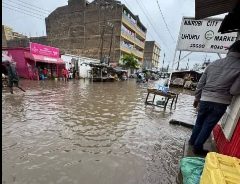
The Ministry of Interior has identified 37 areas in Nairobi City as highly vulnerable to flooding, following heavy rains that have wreaked havoc across parts of the county.
According to a statement released by the Interior Ministry on Sunday, March 15, 2026, the mapping exercise was conducted under the Nairobi Rivers Regeneration Programme to pinpoint neighbourhoods located along major river corridors and other flood-prone locations.
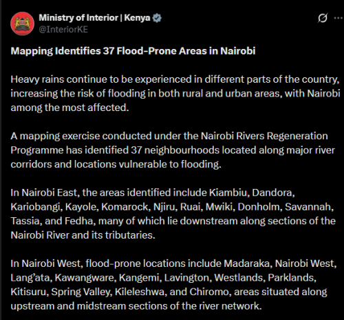
In Nairobi East, the areas identified include Kiambiu, Dandora, Kariobangi, Kayole, Komarock, Njiru, Ruai, Mwiki, Donholm, Savannah, Tassia, and Fedha. Many of these lie downstream along sections of the Nairobi River and its tributaries.
“Heavy rains continue to be experienced in different parts of the country, increasing the risk of flooding in both rural and urban areas, with Nairobi among the most affected.”
You Might Also Like


“A mapping exercise conducted under the Nairobi Rivers Regeneration Programme has identified 37 neighbourhoods located along major river corridors and locations vulnerable to flooding.”
Nairobi floods
Nairobi West has also been flagged, with flood-prone locations including Madaraka, Nairobi West, Lang’ata, Kawangware, Kangemi, Lavington, Westlands, Parklands, Kitisuru, Spring Valley, Kileleshwa, and Chiromo. These areas are situated along upstream and midstream sections of the river network.
“In Nairobi East, the areas identified include Kiambiu, Dandora, Kariobangi, Kayole, Komarock, Njiru, Ruai, Mwiki, Donholm, Savannah, Tassia, and Fedha, many of which lie downstream along sections of the Nairobi River and its tributaries.”
In the Nairobi North corridor, Mathare, Korogocho, and Lucky Summer have been highlighted, particularly along the Mathare River, where dense settlements closely border the river banks.
Nairobi CBD
Within Nairobi Central, locations along the river corridor include the Central Business District (CBD), Globe, Gikomba, Eastleigh, and the Industrial Area, where the Nairobi River passes through.
In Nairobi South, the mapping identifies Kilimani, Kibera, South C, South B, Mukuru Kwa Reuben, and Kwa Njenga, mostly along the Ngong River corridor.
Multi-agency disaster response teams continue to coordinate relief and response efforts. Residents living near rivers and in low-lying areas have been urged to remain vigilant and prioritise safety during periods of heavy rainfall.
“As multi-agency disaster response teams continue to coordinate relief and response efforts, residents living near riparian and in low-lying areas are urged to remain vigilant and prioritise their safety during periods of heavy rainfall.”
Ruto’s message to flood victims
On the other side, President William Ruto has assured Kenyans affected by the ongoing floods that the government will continue to provide support as heavy rains wreak havoc across the country.
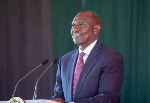
In a statement shared on his social media pages on Sunday, March 15, 2026, the president acknowledged the impact of the severe weather:
“The ongoing heavy rains affecting several parts of our country continue to put lives and livelihoods at risk. My thoughts are with the families and communities that have already been affected during this difficult period,” Ruto’s statement read in part.
He further assured citizens that the government remains fully mobilised to respond.
The Kenya Red Cross has reported that 11 people were rescued across different areas on Saturday night, March 14, 2026, after being caught in the floods.
Death toll as a result of the ongoing floods has now surpassed 60.
Author
Latest News


Advertisement
More on News