Kenya Met issues flood alert for Tana Basin amid heavy rainfall forecast
By Faith Lagat, April 27, 2026The Kenya Meteorological Department has issued a high flood risk alert for the Tana River Basin following forecasts of moderate to heavy rainfall over the next seven days.
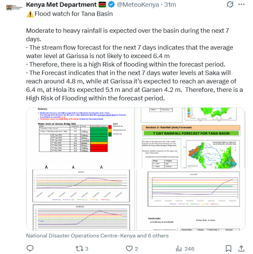
In its River Tana Weekly Flood Watch Update, the Flood Forecasting and Early Warning Centre warned that the basin is likely to experience flooding between April 28 and May 4, 2026.
Rising river levels expected
The bulletin indicates that rainfall will affect both the upper and lower sections of the basin. Stream flow forecasts show that water levels at Garissa Bridge are expected to rise significantly, with projections indicating they may reach an average of 6.4 metres.
“Moderate to heavy rainfall is expected over the basin during the next 7 days. · The stream flow forecast for the next 7 days indicates that the average water level at Garissa is not likely to exceed 6.4 m · Therefore, there is a high Risk of flooding within the forecast period,” read the bulettin in part.
Forecasts for other monitoring points show water levels at Saka at around 4.8 metres, Hola at 5.1 metres, and Garsen at 4.2 metres within the same period.
Current readings show water levels at Garissa Bridge stood at 2.8 metres at 8am, with a falling trend. However, levels are expected to begin rising from April 29, reaching 4.5 metres by May 1, before peaking at 6.4 metres on May 2. The risk category is projected to shift from moderate on May 1 to high between May 2 and May 4.
Rainfall forecast across regions
Areas expected to receive rainfall include the Highlands East and West of the Rift Valley, Nairobi, the wider Rift Valley, the Coast, and Northeastern Kenya.
The forecast also indicates the possibility of intense storms in some regions, which could result in flash floods, rising river levels, reduced visibility, and landslides, particularly in the Aberdare ranges and Mt Kenya region.
“Rainfall is expected to continue across several parts of the country… Heavy rainfall events are likely in some areas,” the Met Department stated.
Flood risk classification
According to the bulletin, flood risk levels at Garissa are categorised based on water levels. Levels above 5.0 metres fall under the flood warning category, indicating flooding is imminent. Readings between 4.0 and 5.0 metres are classified as alert levels, while levels below 4.0 metres are considered safe.
Residents living in flood-prone areas along the Tana River have been advised to remain vigilant as the situation develops.
The department has cautioned the public against walking through moving water, taking shelter under trees during storms, and urged close monitoring of river levels even in areas not directly experiencing rainfall.
The Flood Early Warning System Team advised residents to keep track of updates as conditions evolve during the rainy period.