Redefining food sector the digital way
By Bernard Sigei, July 20, 2022Technology and data use has began gaining traction in the agriculture sector, but the uptake is still low when it is compared to industries such as finance.
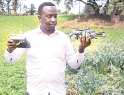
Steve Korir better known as “Kory the Satellite Farmer” is the founder of Data-Driven Agriculture. He has innovated a technology that uses sensing and data science to create products around the agriculture field in a bid to optimise resources used in the sector.
The application of the technology ranges from crop type classification, collection of agricultural-labelled and geo-referenced data sets, yield production as well as crop health monitoring. It can be applied from one’s comfort zone as long as they have smartphones and reliable internet connection.
Creation and monitoring
“In agriculture we can create some models using a number of algorithms to create crop type maps, yield estimation maps and crop monitoring,” says Korir, adding that farmers can also employ computer vision and deep learning techniques to delineate farm boundaries.
The geospatial data scientist from Eldoret says that the invention can make farming less backbreaking by providing aid such as precision farming. This, he explains, will digitalise the traditional methods where people had to use observation techniques to check whether their crops were stressed or had been infested.
With the proliferation of technology in agriculture including remote sensing, a farmer can create digital tools such as the use of Normalised Difference Vegetation Index (NDVI) derived from satellite imagery to monitor crop health over time and detect when something is wrong.
He further points out that to easily predict maturity of crops in different areas using Growing Degree Days (GDD), which is the amount of heat accumulation necessary for certain crops to grow and the precise production happens once the farmer gets the temperature data. Crop Cut Experiment shows the yield of the farm.
“If the farmer does farm boundary capture they create a registry of agricultural-labelled data sets including GDD among others to predict yield model and crop health monitoring,” he remarks.
The sensed imagery eases the famers’ work by use of drone over farms and identifies areas of the farm that are performing poorly, zero in to those areas, study and apply corrective measures. The farmers will able to detect pests and diseases, water stress and identify an indicator for soil nutrient deficiency even as they also create models that can be used to map out where there are weeds and intercropped plants and the farmer is prompted to take necessary steps to rectify the problem.
Data driven advisory
Start-ups can use such kinds of products to afford consultants with data driven advisory with regards to precision farming for the farmers to optimise the resources at their disposal and produce more food to reduce hunger and feed the ever-increasing population.
The sensed imagery technology will also offer an online market, which is preferred by farmers where they carry out transactions at the comfort of their farms, as opposed at physical markets. This was propelled largely by the onset of Covid-19 pandemic. This is advantageous to them, as they avoid middle persons hence maximising the profits.
Further more, the machine learning and remote sensing helps farmers to create crop maps and yield estimates. This helps in the produce supply chain management as it shows what exactly has been grown in which area, and also the area under production and this will be used to study and manage the supply chain activities. Through this, farmers will also try to do their timings well in order to reap the most out of their ventures.
The sensed imagery enables farmers to get weather forecasts on their mobile phones unlike the past where they relied on televisions to bring them up to date on the same. This seeks to enable them to plan what to plant in advance depending on the kind of weather expected, to avoid running at a loss because different crops do well in different types of weather.
“As the demand for food increases, scarcity of resources becomes rife. Let us all shift to data driven agriculture to optimise the resources at our disposal,” points Korir, while cautioning that use of data in agriculture could also be challenging, especially when it comes to use of earth observation techniques. However, the geospatial scientist aims to integrate data from different sources and give stakeholders farm level intelligence.
Sensitising the farmer
Korir, together with the same-minded individuals, traverses the country and the continent sensitising farmers on the importance of applying data science or big data in agriculture to maximise and avoid unexpected calamities such as severe droughts or excess rainfalls since we are in the climate change era.
Data-Driven Agriculture and other geospatial scientists also have online agrovets where farmers can request for farm inputs and get them delivered to their doorsteps. This has been made possible by innovations around logistics that have reduced the delivery costs.
“The crop maps and yield estimates will enable Non-Governmental Organisations and government agencies to create better policies and plan accordingly as far as matters of food are concerned,” he says in conclusion.
